Bryce Canyon National Park
Bryce Canyon National Park
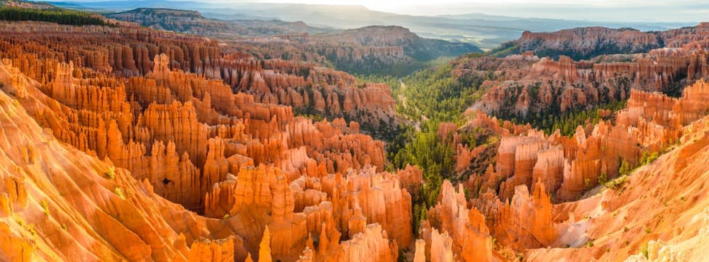
In southwestern Utah, Bryce Canyon National Park hosts the world's largest concentration of hoodoos, sculpted within amphitheatres of red sandstone.
Bryce Canyon National Park, located in southwestern Utah, stands out for its natural amphitheatres carved into red and orange sandstone. Its thousands of hoodoos, these distinctive rock spires, constitute the world's largest concentration of this type of geological formation. The site can be visited year-round, with marked contrast between the hiking-friendly summer and snow-covered winter.
Why visit Bryce Canyon
Despite what its name suggests, Bryce Canyon is not a canyon in the strict sense. It is a succession of amphitheatres carved along the edge of the Paunsaugunt Plateau, itself part of the vast Colorado Plateau. Erosion from freezing and runoff has fragmented the sedimentary rock into columns, arches and walls whose hues range from white to dark red depending on the light.
The park combines several interests: spectacular geology, a preserved night sky (one of the darkest in the États-Unis, prized for astronomical observation), high-altitude biodiversity (the park rises above 2,700 m) and accessibility via a network of scenic drives and marked trails.
Park History
The earliest human traces on the plateau date back several millennia, though without confirmed permanent settlement. In the 2nd century, Fremont cultures to the north and Anasazi to the south structure regional occupation. By around the 12th century, Native American groups establish themselves permanently and live by gathering and hunting.
Western exploration begins in 1872 with the expedition of John Wesley Powell, who maps the area. Three years later, in 1875, the Church of Jesus Christ of Latter-day Saints sends carpenter Ebenezer Bryce to help local settlers: he constructs a canal against flooding and builds a road. Residents give his name to the place. Bryce, unmoved by the site's beauty, uttered the phrase that remains famous: « it's a hell of a place to lose a cow ». He leaves the region for Arizona in 1880.
Later, J. W. Humphrey, of the National Forest Service, discovers Sunset Point and works to publicize the site: « You can perhaps imagine my surprise at the indescribable beauty that presented itself to our eyes, and it was sunset. I could not tear myself away from the view of the canyon ». The site is designated a national park on February 25, 1928. Tourism truly takes off in the 1930s, with the development of accommodations and the creation of roads connecting Bryce to other parks in the region.
What to see and do
Main viewpoints
Six viewpoints provide a progressive view of the main amphitheatre, all accessible from the park's scenic drive:
- Fairyland Point: located outside the pay zone, it offers a first perspective on the hoodoos.
- Sunrise Point: starting point for the Rim Trail, ideal at dawn when the pinnacles are tinted pink and orange.
- Sunset Point: most frequented overlook, with sweeping views of the Silent City area.
- Inspiration Point: about 1.2 km from Sunset Point, panoramic view over a long chain of hoodoos.
- Paria View: facing southeast, it overlooks a quieter secondary canyon.
- Bryce Point: 2.4 km from Inspiration Point, it offers the most comprehensive view of the amphitheatre. End point of the Rim Trail and starting point of the Peek-A-Boo Loop.
Hiking trails
Several routes allow you to descend into the heart of the formations rather than viewing them from the edges:
- Queens Garden Trail: the least demanding descent to the hoodoos.
- Navajo Loop: a short and spectacular loop passing through the Wall Street area.
- Rim Trail: a ridgeline path connecting Fairyland to Bryce Point, adjustable based on desired distance.
- Peek-A-Boo Loop: a longer circuit, also open to horseback riding.
The Scenic Drive, a panoramic road along the park's south side, serves the most distant viewpoints and is an alternative for visitors with limited time.
Practical Information
The park is open 24 hours a day, year-round. Entrance is paid and the ticket, valid several days, provides access to all viewpoints, shuttles and trails. The annual America the Beautiful pass is worthwhile if you visit multiple southwestern sites. Camping and horseback rides are charged separately.
A free shuttle serves the main viewpoints from the visitor center during high season. It is strongly recommended to reduce vehicle pressure on the site, which welcomes over one million visitors annually. Private vehicles remain permitted, but parking at the most frequently visited viewpoints can be full mid-day.
When to visit
The park can be visited year-round, but the experience varies greatly by season:
- May through September: optimal conditions for hiking, long days, pleasant high-altitude temperatures. This is also the most crowded period.
- October and April: good light, reduced crowds, but cold nights and possible snow.
- November through March: the park becomes snow-covered, creating striking contrast with the red rock. Cross-country skiing, snowshoeing and sledding are practiced here. Some secondary roads may close occasionally.
How to get there
The most convenient airports are Las Vegas and Salt Lake City. From Las Vegas, allow approximately 4 hours of driving. Car rental is almost essential to reach and explore the region.
Route 12, which connects Bryce Canyon to Red Canyon State Park, ranks among Utah's most appreciated scenic routes. From Zion National Park, the itinerary uses highway 9 then 89. From Capitol Reef, you reach Bryce via highway 24 then Route 12.
Surrounding Areas
Bryce Canyon fits naturally into a regional circuit. Visitors often combine a visit with Zion National Park, located about two hours' drive away. In the immediate vicinity, Red Canyon, Cedar Breaks National Monument and Kodachrome Basin State Park offer comparable sandstone and amphitheatre landscapes, with far fewer crowds.
Frequently Asked Questions
Frequently asked questions
Half a day is enough to tour the main viewpoints by car or shuttle. Budget a full day if you want to add a hike like the Queens Garden / Navajo Loop combination, and two days to explore more thoroughly, including the Peek-A-Boo Loop or less crowded areas in the park's south.
Yes. The park remains open year-round and the main viewpoints stay accessible. Snow transforms the landscape and allows cross-country skiing and snowshoeing. Bring warm clothing, chains or appropriate tires, and check secondary road conditions before departing.
No reservation is required for entry. However, lodging inside the park and campgrounds should be reserved well in advance for the summer high season.
Yes, it's actually the most common formula. Bryce flows logically into Zion, Capitol Reef, the Grand Canyon or the Canyonlands as part of a southwestern États-Unis circuit. The America the Beautiful pass covers all these sites.
Planning your trip
To incorporate Bryce Canyon into a complete itinerary through western parks, consult our États-Unis trips and draw inspiration from our step suggestions to build a coherent circuit.
Interested in this visit?
We can include it in your personalised itinerary.